
WinGIS
As the map question - availability - is solved, with Sentinel, Bing maps, Google maps, local orthoimages, LPIS data or OSM (Open Street Map) or OTM (Open Transport Map), globally available and the customer wants to do more with his maps, a next question will occur: How to manage them within a GIS. Not only the top down but also the bottom up side, this in a manner that the benefit reaches the farmers and other stakeholders.
When the geo-component is decided and ready – e.g. in Europe/US we have WMS services with orthoimages, 30+ cm resolution available, in other regions of the world satellite images with 0,4m, 1, 2, (5)m - that easily can be linked (also other images can be taken), we can start but a map alone is too less. Our spatial engine WinGIS®, the first, very fast and powerful object oriented GIS with its own development environment (SDK) that allows programmers easily to link their db-applications to maps. We focused the developments for the needs where we have been coming from – out of a consultancy office, focusing on agriculture – forestry - environment and natural risk-management.
As the most complex markets within the GIS sector, one has to understand the needs of the different chain partners within this market. A map alone is too less and does not help and cooperation of chain-partners is a must! You also can beside using WinGIS – we have lots of customers around the globe that use WinGIS alone and manage their ground-assets with the GIS only – choose our applications or one initiates the setup of an installation on a region- or countrywide level and or develop own applications with the help of our SDK.
There are hundreds of functionalities available for experts, advisors, farmers and even tractor drivers. You choose which to use
Raster and Vector

As object oriented system WinGIS was one of the very first worldwide to be able to handle raster and vector maps in an unlimited numbers of layers.
Functionalities

Beside standard functionalities such important as krigging, Import and Export like DXF or Shape, GPS handling, etc. allow all work needed for the management of agriculture, forest, environment and natural risks.
An internal Database (IDB) allows a fast start, more complex applications can be linked with an AX component
Large Sentinel II Images
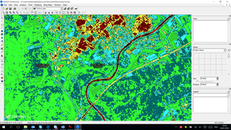
Also with huge files WinGIS works extremely fast