
Shows how forest management and forest inventory can be setup for forest enterprises or entire countries
In Austria we have beside many small forest owners (mainly farmers with forests) and around 20% of the forest area with government forests several thousand forest owners between 50 and 30.000 ha. Many of them use the PROGIS ForestOffice for forest management and forest inventory Some of them use just WinGIS with the embedded internal database (like a spreadsheet) and use either BING maps or local available ortho-images and produce their forest map and link the information of the different stands. Larger enterprises use the linked forest database that uses growth tables – they can be modified by country – and do a precise forest inventory and with the upgrade – yearly cutting and growth updated - run a permanent inventory that tells them stocking, growth, cuttings, afforestation etc. Naturally the entire system is also used for many forest management questions like road management, cutting planning etc.
For countries that have no yield power growth tables we also support to setup such tables and integrate them into the system so that with simple Relaskop-measurements (Dr. Bitterlich) and these tables the stockings and growth can be calculated automatically.
Beside forest enterprises also many consultants use our software for the setup of a forest inventory for small or midsized forest enterprises that do not want to do this job themselves. Further - the forest inventory and the setup-costs are also supported by the government.
Forest-map
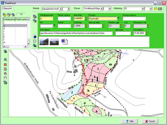
A good forest map contains the single elements with their size, the department- resp. management-zones, all the border-lines and border-stones, the road- and path-network etc. and must be able with the GIS support to generate different thematic map.
Sub-department
Age-map is one of the most important thematic maps that shows the different ages in groups of 20 years (0-20, 20-40, 40-60, 60-80, 80-100, 100+) in different colors. The forest inventory module enables all the variables to define according the local necessities. This is valid for all data to be collected from the ground (inclination, exposition, size (from GIS integrated), soil-class, stand quality, humidity etc.) or for the trees (sorts, bonitaet, growth degree (in relation to table), height and age etc.)
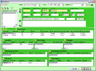
Database
A search through the database can give you in few seconds a new map showing all your interested elements, e.g. where is which specific sorts in a specific age.