
DokuPlant - THE farmmanagement tool
As next step in a planned setup of systems, the farm- and/or forest-management has to be set in place taking into account the needs of different users next to farmers/foresters. Some of them will be able to run it alone, some of them will need help and support = get advise.
A new possibility shows up for advisory services, independent if public or private. They will work as service providers for the stakeholder group within a region, using state of the art technology. With such a model, country coverage can be established in shortest time. Beside advisory service, also large farms or even food-industries can guide this service processes as everybody will benefit of it. If once a model is ready, WHERE, WHAT and WHEN an activity must be done - an enlarged GIS application is needed – the advisor/service provider will support this process from distributing seeds or fertilizers till the use of machines.
DokuPlant® does business calculations, nutrient and/or carbon balances, cost calculations, subsidy management if integrated (local support needed) or even business plans, supporting insurance companies or banks and creating local or regional maps. The data come from expert models done together with local experts.
DokuPlant® has as fundament the GIS-based local LPIS (Land Parcel Identification System ), further an integrated expert database (with all relevant agricultural data and cultivation recommendations supported by local expert partners) and a perpetual documentation tool. With this FMIS tools, extension officers are enabled to plan and control every field with a click, for a farm, a region or an entire country.
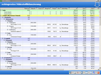
Following information will be generated from every field and can be accumulated for the entire country: Activity management, crop rotation, cost calculation, nutrient balance for N, P, K, Ca, Mg and carbon balance. Models are ready to support carbon balances for countries to enable carbon financing for them based on measurable indicators and if needed energy balance, input/resource needs, harvests results etc. The (1) PC-GIS, (2) real-time management and the (3) expert-data base are integrated within the FMIS database application.
The mapping of plots/fields will be supported and a perpetual calendar enables the display of any performed activity: what – when - where. The integrated database is filled with agro expert data, generated in close cooperation with local agro-forest-environmental scientists/experts. It contains e.g. for Germany 2.500 agro-machine data (from KTBL, costs, time, …), data on thousands mineral-/organic-fertilizers and crops incl. varieties, 850 pesticides with chemical contents and 400 plants with average yield and seed needs. Further, it includes the prescribed complete working process for a year or beyond with all activities and resources. It is pre-defined for all crops and enables planning with one click: Where (plot in the map) do I plan what (select crop from the expert data bank). Individual farmers can modify the expert data at any time. The expert data will be modified by local experts within an integrated business model.
You are interested to cooperate with us or a local expert, send your request to office@progis.com
DokuPlant Overview

DokuPlant contains 4 elements that are deeply integrated:
Nutrient balance
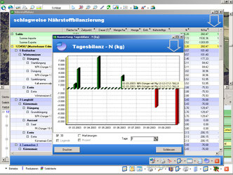
enables the nutrient balance for N, P, K, Ca, Mg; at the moment we are working on an additional carbon balance to enable a countrywide carbon modelling
(****) Cost calculation – can work with any currency of the world and gives detailed information of costs and revenues on a click.
Subsidy Integration
can be managed with local software partners that are able to integrate the local subsidy tool into our DokuPlant
1. A GIS element that enables to integrate orthoimages, LPIS data (digitized Land Parcel Information System in EC) or any other vector data like your digitized fields, soil maps, meteorology maps etc.
2. A timeline that enables to show all the activities, represented by icons on a timeline on your field and move the timeline into the future for planning or into the past for your documentation that you also know what happens on this field (or a part of it) years ago.
3. A database that stores all the activities planned or later done on a specific field and enables to investigate not only your field but your farm, a group of farms, selected by the db or by the GIS or integrate the data later for an entire country. Lots of graphic supports the interpretation of your data.
4. The expert database link that is based on machinery and its costs, organic and inorganic fertilizer with their chemical contents, brand names and costs/kg. Further the pesticide data with all the legal available pesticides and their chemical active substances and all seeds and varieties as well as the management-methods to integrate all these elements on the timeline: What to do When and Where with which resources. This enables to plan with one single click: Where to grow what and all the expert data become part of the future calculation(s) – for a field, a farm, a group of fields, a region or even a country: Create cost plans, nutrient balances, carbon balances under development etc.. You do not only know what you need and how much of it but also you know where you need how much what is the fundament for every logistics planning to distribute it with further optimized logistics – see also our logistic part!