
Precision and/or Smart Farming (PF/SF) with enhanced NDVI
PF means that we can distribute on existing technology not only a contract where to drive and what to do but also a map, a Precision Farming map as integrated next step. The key question will be who is managing these maps? Deep agricultural know hows necessary. Not the machine is intelligent, it is the map that brings the know-how to the machines and we need information: Soil analysis with GPS, previous-, following and in-between-crop, crop residues on the field with their chemical content, satellite information regarding chlorophyll content etc. With these inputs agro-experts are able to create fertilizer maps and/or pesticide maps for site-specific management. The integration of the new CFM (Circular Flow Management) model of PROGIS with the integration of NIRS backed labs for feed-, manure- and soil-analysis gives the necessary input for PF based maps, otherwise PF stays incomplete.
A new possibility is the integration of the EC Sentinel satellite image data with 10m resolution that embeds the chlorophyll content of a field or even the soil moisture. This information can be downloaded all 5 to 10 days with an upgraded map and the access to the data can be managed free of charge by PROGIS, just the service has to be paid. A customer gets as a service an email if a new image is available and gets it delivered on a click and can be used as fundament also for precise farming together with other data the farmer might have. The service can´t be done for a single farm or field but for large groups of farmers or regions what also reduces the price to cents per ha. First time we have the chance to use satellite data as fundament for PF for an entire country!
If wanted the following next step can also be implemented on top: Virtual farming®, the optimization of fields with neighbors together. Create larger and better shaped fields, split with calculation of verified costs and revenues per m² according PF-documentation of activities (=costs) and harvest results (=returns) to increase farmer´s profit.
Based on Sentinel images and the NDVI growth index and the overall integration into WinGIS, a new module for crop monitoring was developed that is based on soil line evaluation and increases the quality of the results 30-35% compared with the standard index methods. Enlarged with other data like soil maps, lab analyses, data from DokuPlant (history, future plans, harvest maps, zoning etc.), it is THE tool for Precision Farming.
Harvest map
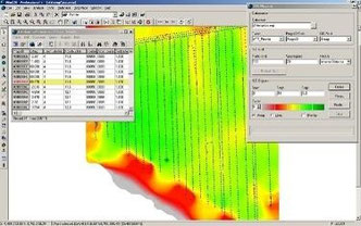
A harvest map can be the entry point for precision farming if anything else is not available; it shows the results in t/ha in different colors and might display also the route of the machine as protocol for the amount of meter or hectare done.
Agricultural know-how

A farmer or if not able an advisor/expert can work out based on the know how of the crop the crop rotation, the situation of the last years, the plan in the future (= DokuPlant), the sentinel NDVI index (= WinGIS Lumen), the meteorological forecast (Pessl weather-station and forecast model) etc. a new map that can be transferred to mobGIS.
Bluetooth transfer
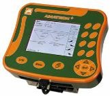
From there it triggers via Bluetooth transfer a mobile device of a fertilizer distributor or a sprayer. After the work is finished, a protocol in form of a map is transferred back to DokuPlant.